
It may seem strange to fixate first on the land holdings in Ohio and not the narrative of settlement, but there is a reason for my doing things in this order. Land was fundamental to why the original 11 Armstrong emigrated from Ireland, and its availability in the US Military District in Ohio was the main attractor to this specific location. Moreover, the gradual acquisition and distribution of the Ohio farmlands reveals the solidarity among the first generation as well as Alexander Armstrong’s consistent leadership in providing for his family. By the end of his life, he had settled every one of his five children and his nephew on a farm of their own, all within five miles of each other. From a first acquisition of 150 acres, these farms grew to a total of around 1,150 acres, with sown crops, apple and peach orchards, livestock, and timber providing comfort and livelihoods to the growing extended family. The very thing that seemed impossible in Ireland for generations was made possible in America within a few decades for every one of them: to own land enough to live on and prosper.
In this installment, I will focus specifically on the acquisition and location of the Armstrong farmlands, with indications of how to locate them today. The next installments will then convey the narrative of their settlement, their marriages and experiences on the frontier. The sources for this information are: the record of land sales for the Military District; a digitized map of Muskingum County in the Library of Congress from 1852 (significantly, the year of Alexander Armstrong Sr.’s death); township maps from Atlases of Muskingum County from 1866 and 1875; and anecdotal information from the 1890s, when remaining family members like William and Alexander Jr. were still around to recount the history of their farms and the settlement of their townships. To date, this is, I believe, the most accurate accounting of this extraordinary history of family settlement. They were not land barons by any standard, but were successful in their modest, Methodist way at implanting their Irish family on American soil.
1. Square One: Perry Township and the Original Farm
The first fact is this: On November 15, 1809 Alexander Armstrong purchased 150 acres of land in the US Military District of Ohio at $2.50 an acre. Specifically in the language of the military land survey, the land was range 6, township 1, the southeast quarter of section 13, a notional square of property .5 miles per side. This was just over a half mile down the Wheeling Road from the Big Salt Creek crossing, and about eight miles from Zanesville, at the time the capital of Ohio; it was a judicious choice at a time when so much of this area was uncleared forest. If they had come from Pittsburgh over land via the Wheeling Road, they might have spotted this land themselves on the way to the land office in Zanesville. Brown’s tavern was at the crossing nearby, and the Livengoods had already set up a saw mill down the creek. Eventually, a hamlet would grow up, named Bridgeville for the obvious reason that a bridge was there. The 1852 map of Muskingum County shows the hamlet and how the Wheeling Road, by then the National Road, bisects the Armstrong land diagonally. The land that year is in the name of John Armstrong, which fits the 1850 census information that reveals John was by then head of the household taking care of his elderly parents, Alexander and Catherine.

1852 Map of Muskingum County (Library of Congress) showing the original farm now in the name of John Armstrong. This was the year of Alexander, Sr.’s death. The dots above the roadway designate it as the National Road
An 1866 Atlas reveals more detail, but by then John Armstrong had died (1861) and the land passed to Alexander’s grandson, John Robinson McCurdy, Elizabeth’s son. Here we see two houses located on the McCurdy land, as well as the locations of the grocers in Bridgeville, the tollhouse near the Salt Creek on the National Road, and the saw and grist mills down the creek.
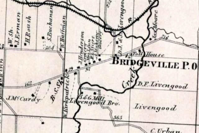
1866 Atlas showing J. R. McCurdy’s land near Bridgeville. He acquired it after the death of his uncle John Armstrong in 1861.
The best schematic image of the land is from the spectacular 1875 Atlas of Muskingum County, which gives more detail as to the position of the house, the spring near which it was constructed, and the orchard on the farm. The original pioneer houses were normally constructed near springs if they existed on the property, and this clearly shows a tributary to Salt Creek. We also see nearby the stores of Stires and Mock, the latter of which had become the Post Office. The circle with an x marks a blacksmith’s shop. The acreage is given as 148, some 12 acres having been sold off on the southwest corner on the far side of what is Spry Road today.
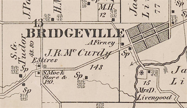
1875 Atlas of Muskingum County showing Alexander’s grandson’s farm
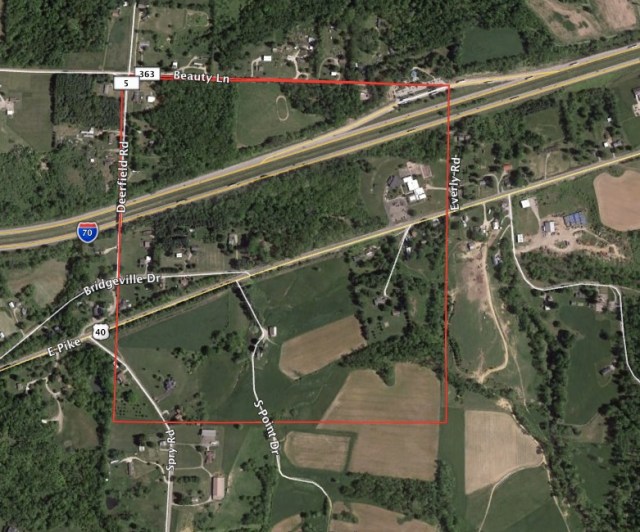
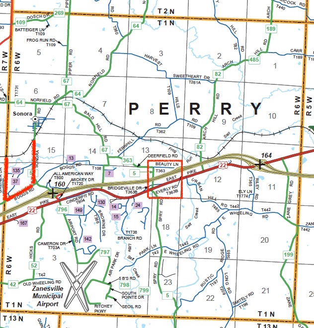
It is perhaps an historical irony that Alexander chose the land so well for its connection to the Wheeling Road—in short time to become the National Road—that now the land is hard to discern amongst all the subsequent transportation development. Not only is US Route 40 (here marked 22) or East Pike still crisscrossing the land, but now Interstate 70 plows through it as well. To the north you can still see the railroad that was the original Central Ohio line, which had its local station in Sonora (thus killing the future of tiny Bridgeville). To the southwest, the Zanesville Municipal Airport has taken over the southwest corner of the township. So it is not an exaggeration to say the Armstrongs arrived and set up their first house at an historical crossroads, near the dead center of Perry Township. Today, the northern and western boundaries of the farm are still marked by Beauty Lane and Spry Road.
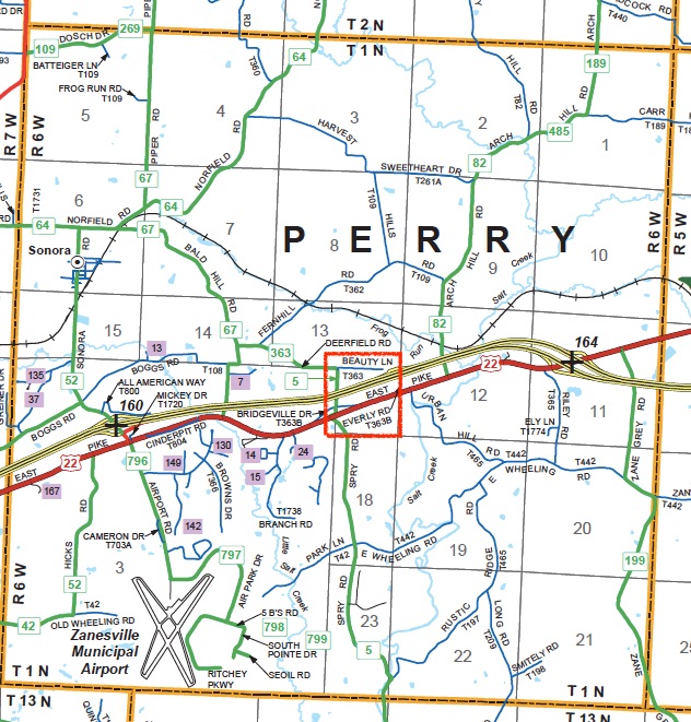
Perry Township today, with the original Armstrong farm located within the red square
2. Salem Township and the Other Original Purchases
We have two more facts from which to start: on December 7, 1814 James Armstrong purchased 160 acres in Salem Township, just to the north of Perry Township, specifically the southwest quarter of section 20. Then three months later, Alexander Armstrong purchased 159.72 acres, the southeast quarter of section 12 in Salem Township, on March 4, 1815. These were remoter tracts at the time, and took a while to develop; but they were the origins of two farms that would stay in the family for many decades. Two additional purchases made so early on might seem surprising, but one thing may have helped the brothers to make these acquisitions: from 1810 to 1820, federal land could be bought on credit. James meant his quarter section for his own family; upon James’ early death in 1826, it was farmed by his older son Leslie for forty years until his death in 1866, then by Leslie’s heir Edward Brock to his death in 1901. Alexander’s quarter in Salem Township would become in time the flourishing farm of his third son, William, who would expand upon it with cash purchases of contiguous land strips and end up with some 268 acres at its height. Assuming the original 11 Armstrongs—12 with the birth of Alexander, Jr. in 1810 right on the first property—spent their early days on the farm in Perry Township, there would have been both help enough to develop new land as the boys became teenagers, and the pressing sense that more land was needed to meet the demands of a growing family.
In the 1820s, the family made some smart business decisions that brought in some decent profits. In 1826, Alexander purchased a load of wheat which they milled into flour and loaded onto a flatboat at Zanesville, and William and perhaps James went with the crew to sell it in New Orleans. It sold for $3.25 per barrel, and they turned a good profit on this venture, though it took 44 days to reach New Orleans and doubtless some time to return. With this profit, Alexander purchased the southeast quarter of section 19 in Salem Township from Peter Wolford on the upper reaches of Salt Creek, where an Indian camp had been for some time. In 1827, Alexander negotiated a contract to build part of the National Road between Bridgeville and Zanesville, which his sons helped to supervise and work on; this again turned a handy profit. At some point James, the son of Alexander, purchased the other southern quarter of section 19 from Fred Wolford, allowing him to double the size of his lands. The result of these ventures and acquisitions was a sizable nexus of Armstrong farms in Salem Township. We have record of another acquisition by Alexander up in Adams township of 85 acres, but it is not clear what the purpose was; by the 1852 map, it is no longer his, so perhaps he just solid it off later at a profit.
If we match up the acquisitions and settlement of these farms with the marriages, we can see basic pattern. Elizabeth was married off early at 17 on New Year’s Eve of 1818, while James married in 1826 at 25. The latter marriage falls at the time of the grain sale and New Orleans adventure, so it stands to reason that this was in part to prepare James for a farm and life of his own. Whether the death of Alexander’s brother James in 1826 had anything to do with this, we don’t know. William married in 1832 at 26, after having helped with both the grain sale and National Road contract, and moved up to the farm in Salem township, section 12. This had been rented out in 1821 for seven years to “Little Robert” Cowden, who had erected a crude log cabin in a single day; it remained there and was the young Armstrong couple’s first marital home. By contrast, their cousin Leslie wasn’t married until he was 40, perhaps because he struggled from the age of 23 to sustain his father’s household upon the latter’s early death in 1826. When Leslie’s cousin James settled in the adjacent farm very shortly afterwards, we might wonder if this was meant to give aid and comfort to Leslie up in what was still a remote area. Leslie finally married in 1843, but then his neighbor and cousin James died at 47 in 1848, leaving his own 19 year-old-son Alexander in the position young Leslie had been at age 23. By then, William was well established up the road, and seems to have been a real comfort to his nephew, no doubt owing to the fact that the young Alexander’s mother Margaret and William’s wife Isabel were sisters. All the same, this Alexander would be the one Armstrong to uproot and leave the area completely; for reasons still unclear to us, he packed up his family and moved overland by wagon to Illinois in 1868, selling his quarter section to Richard Haynes. Alexander’s mother Margaret Moore Armstrong, however, persisted on her quarter, and passed it to her daughter Mary. At some point after 1875, it passed to Mary’s elder sister, Elizabeth Armstrong Bowden and her husband Charles Bowden, who held the property after Elizabeth’s death in 1888 into the next century.
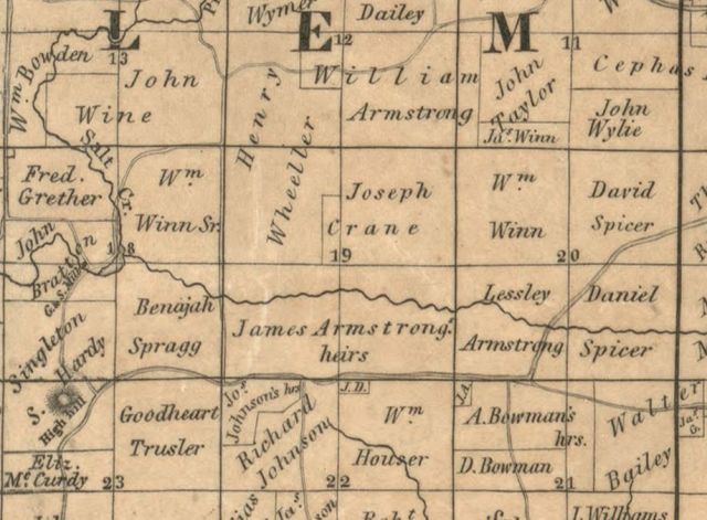
1852 Map of Salem Township (Library of Congress) showing farms of William Armstrong (top center, section 12), the heirs of James Armstrong (son of Alexander) in section 19, Leslie Armstrong in section 20, and in section 23 the property of Elizabeth Armstrong McCurdy
William Armstrong had no son of his own, but passed his property on to his grandson John W. Elsea (William’s daughter Catherine died young in 1860 of scarlet fever). Leslie Armstrong and his wife Jane were childless; Leslie left the property in his will of 1866 to his wife in lieu of dower, then after her death, to their (virtually if not legally) adopted son Edward Brock, who as mentioned, held on to the property into the twentieth century. Jane seems to have passed the property on to Edward quite early, as it is already in his name in the 1875 Atlas, though she remains listed in the census documents as a member of the household. Leslie also left some additional acreage to his younger brother James, who seems also to have sold out to Brock. This James’ mysterious absence from the land records leads me to believe he never became a farmer, and instead took up another line of work; my suspicion is he became a Methodist minister.
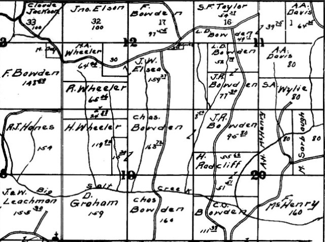
William Armstrong’s farm in 1866 with the additional lands purchased
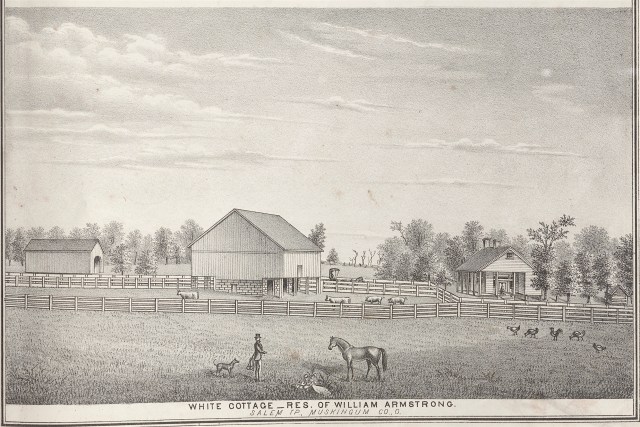
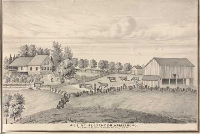
Idyllic Engraving of William Armstrong’s Farm in 1875
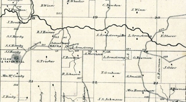
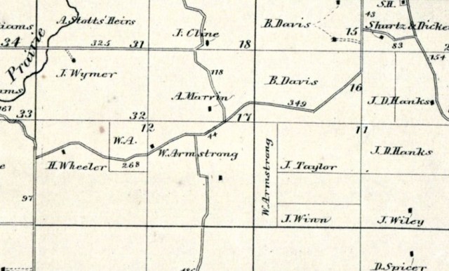
James Armstrong’s property in 1866 as divided between son Alexander and widow Margaret (sec. 19); Leslie Armstrong’s property with additions in secs. 21 & 22; Elizabeth Armstrong McCurdy’s property in sec. 23
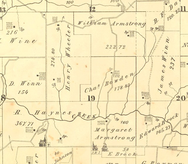
William Armstrong’s farm in 1875; Margaret Armstrong’s farm is there, but Alexander’s has been sold; Leslie Armstrong’s farm has now been left to Edward Brock, along with the additional acreage he had left to his brother James Armstrong, near the schoolhouse.
Salem Township in 1916, showing J. W. Elsea now in possession of his grandfather William Armstrong’s farm in sec. 12; Charles Bowden now owns his mother-in-law Margaret Armstrong’s farm; Edward Brock’s farm (originally Leslie Armstrong’s) now in Bowden hands as well.
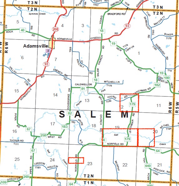
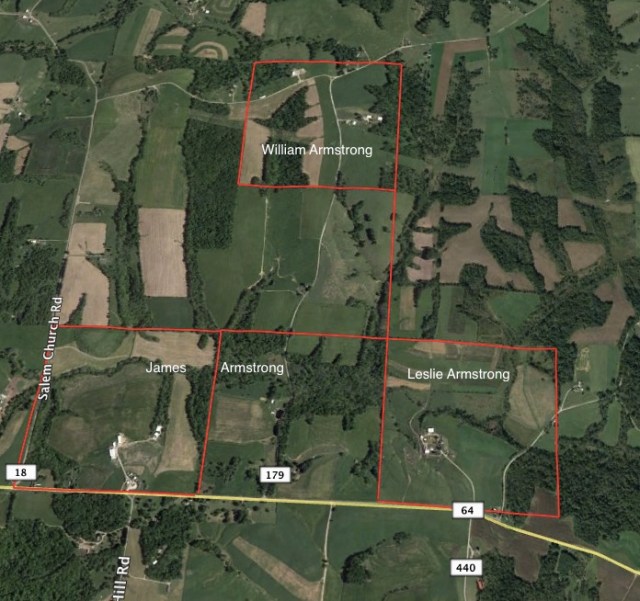
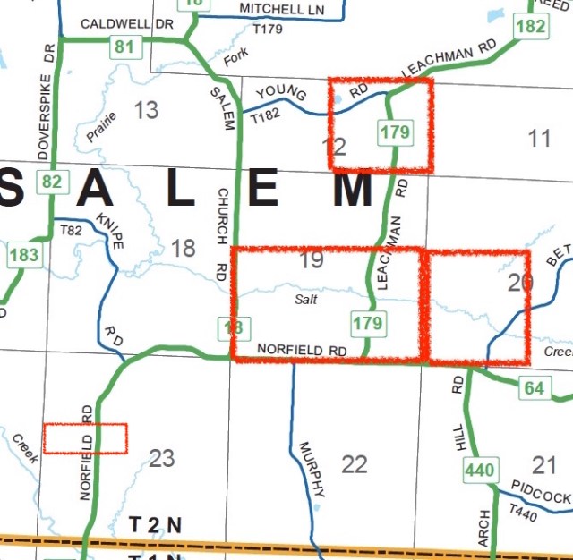
Farm locations today, traceable by following Northfield Road north to Leachman Road.
3. The McCurdy Farm near Drummond’s Knob
The northwest quarter of section 23 holds the distinctive eminence known variously as High Hill, Hardy’s Tater Hill or finally, when William Drummond bought the property, Drummond’s Knob. 60 acres of this quarter became the homestead of William McCurdy and Elizabeth Armstrong McCurdy, Alexander and Catherine’s eldest child. Family historians say this was conveyed to them by Alexander in 1848, thirty years after their marriage in 1818, and in the year her brother James died. The 1830 census shows a William McCurdy family of 7 living in Perry Township, which corroborates the notion they only later moved their large family up to Salem Township. This 60-acre farm is by far the smallest land holding amongst all the Armstrong lands, but this is probably because William was a blacksmith by trade, not a farmer, and didn’t need as much land to make a living. The convenient location along the road may have been advantage enough. Upon William’s death in 1863 at 74, the widow McCurdy stayed on that land until her death in 1888, while her son John Robinson McCurdy ended up with the original Armstrong farm in Perry Township.
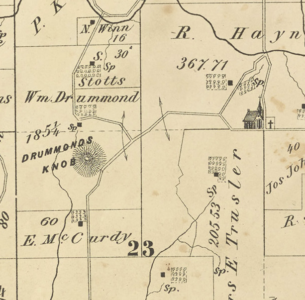
Elizabeth Armstrong McCurdy’s small farm near the hill eventually named Drummond’s Knob by its owner. Around the bend in the road is the Salem Methodist Episcopal Church with its graveyard, and the property once belonging to her brother James. His son Alexander farmed that land until he left for Illinois in 1868.

Drummond’s Knob in 1875, looking south. The McCurdy home would be just over the hill.
McCurdy Farm just off Northfield Road in section 23
4. The Farm in Western Perry Township
From all the maps available, it is clear the 160 acre farm at the western boundary of Perry Township was in the name of Alexander Armstrong, presumably originally Alexander, Sr. then Alexander, Jr., who held the farm until his death in 1896. Alexander Jr. is buried not with his parents in the Methodist Bower’s Cemetery (where William and Elizabeth McCurdy are as well), but rather in the Lutheran Cemetery near Sonora, where he was at one time postmaster. As the youngest of the family and the first born in this country, we might expect he would diverge a bit from his Irish parents and siblings, and the Lutheran burial certainly suggests he ran with a somewhat different crowd over on his corner of the county. He also married relatively late, at 42 and only in 1852, just before the death of his parents.
To date we have no idea how this farm came into possession of the family, but it seems to have been destined for Alexander, Jr. since all the others had been situated: James and William, along with cousin Leslie, in Salem Township, where Elizabeth with William McCurdy joined them; John was clearly destined to inherit the original farm in Perry Township. So Alexander, Jr. was to have his own farm just at the township border, easily locatable once the Central Ohio Railroad ran its tracks along its northern limit.
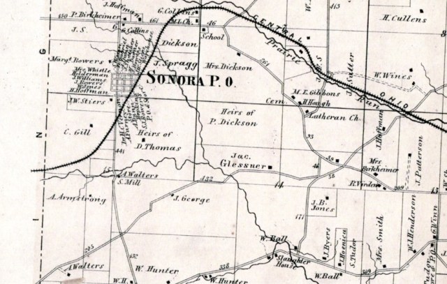
Alexander, Jr.’s farm in 1866 at the border with Washington Township, south of the Central Ohio railroad line. Sonora was laid out in 1852 and had a water tank and station.
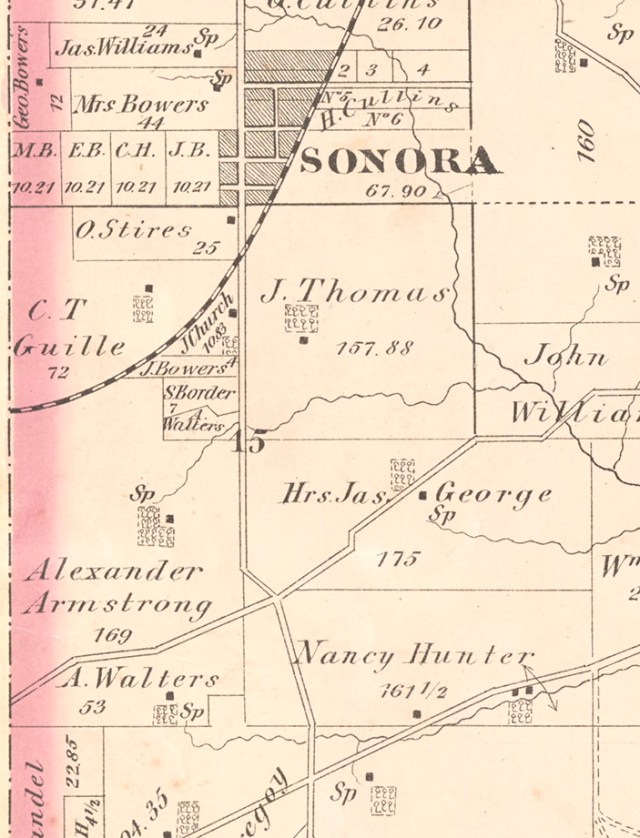
Alexander, Jr.’s farm in the 1875 Atlas
Alexander, Jr.’s farm in 1875 from the same Atlas
Alexander, Jr.’s farm located within the township line, Boggs Road, Sonora Road and the railroad tracks along its northern boundary.
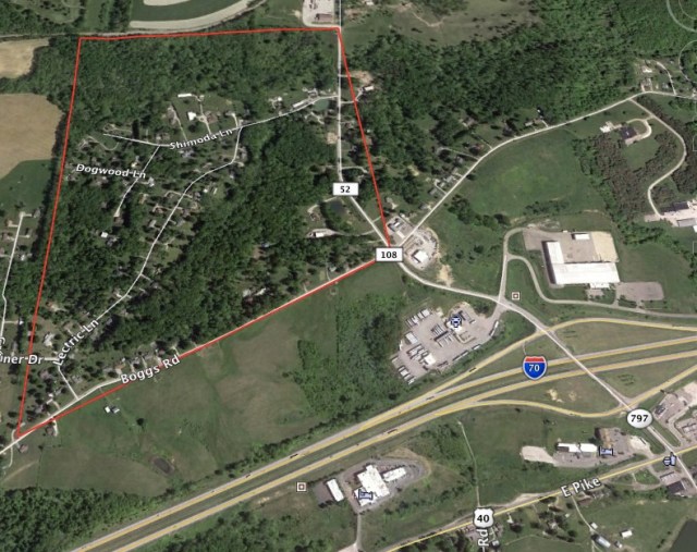
The West Perry Township Farm of Alexander, Jr., bounded by Boggs Rd., 52 (Sonora Rd), and the railroad tracks
Having thus surveyed the land that lies at the heart of this story, we turn now to the narrative of settlement in Part III.
Click here for Part III: The Settlers’ Story [coming soon]
